
OctoMap 3D scan dataset
This dataset repository contains 3D laser scans and final maps for OctoMap (http://octomap.github.com). For compatibility, use at least version 1.4 of OctoMap when viewing or converting these files.
Licence
This dataset is made available under the Creative Commons Attribution Licence 3.0: the licensor permits others to copy, distribute, display, and perform the work. In return, licensees must give the original author credit. See http://creativecommons.org/licenses/by/3.0 for details. By way of attribution, please include an acknowledgement and/or citation for any results published using these datasets.
Contact Information
Armin Hornung
hornunga@informatik.uni-freiburg.de
University of Freiburg
Dept. of Computer Science
Humanoid Robots Lab
Georges-Koehler-Allee 074
D-79110 Freiburg
Germany
Datasets
The datasets below are available in different formats. All of them are gzipped so you need to run gunzip first to decompress them. .graph files contain raw sensor readings at registered poses in a binary format. You can convert them to .bt and .ot (the final occupancy map format) using the tool graph2tree in OctoMap, which also prints out different statistics for the conversion. You can also incrementally build maps from .graph files in the OctoMap visualization octovis. .ot (octree) files contain a final occupancy map in the OctoMap format. The nodes store the full (probabilistic) occupancy information. .bt (Bonsai tree or binary tree) files encode an occupancy map with only maximum-likelihood information (lossy compression), each node is either free or occupied. Both .ot and .bt files can be opened and visualized in octovis.
As an example, to create a 3D map "map.bt" from a scan-graph file "input.graph" at a resolution of 10cm, use:
graph2tree -i input.graph -o map.bt -res 0.1You can optionally limit the maxrange to 10m with "-m 10", see "graph2tree -h" for more options.
-
FR-079 corridor - 360° laser scans (SICK LMS on a pan-tilt unit) of the indoor office environment of building 79, computer science campus at University of Freiburg.
43.8m x 18.2m x 3.3m
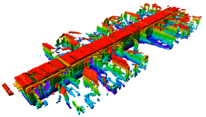
fr_079.graph.gz (117 MB)
fr_079.ot.gz (2 MB, 0.05 m res., created with 10 m maxrange)
fr_079.bt.gz (415 KB, 0.2 m res., created with 10 m maxrange)
-
Freiburg campus - 360° laser scans (SICK LMS on a pan-tilt unit) of the computer science campus at University of Freiburg, outdoor. Original dataset recorded by B. Steder, University of Freiburg.
292m x 167m x 28m
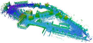
fr_campus.graph.gz (445 MB)
fr_campus.ot.gz (6.3 MB, 0.2 m res.)
fr_campus.bt.gz (1.2 MB, 0.2 m res.)
-
New College - Epoch C of the New College Dataset. Laser data (two vertically mounted SICK LMS 291-S14) on registered robot poses.
250m x 161m x 33m
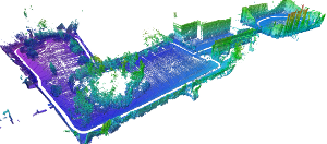
new_college.graph.gz (293 MB)
new_college.ot.gz (3.1 MB, 0.2 m res.)
new_college.bt.gz (602 KB, 0.2 m res.)
-
RGBD freiburg1_360 - Colored (RGBD) data recorded with a MS Kinect in an office environment. The original data is available in the RGBD-dataset and was aligned with RGBDSlam. The final .ot file also contains color information.
7.9m x 7.3m x 4.6m
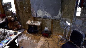
freiburg1_360.ot.gz (8.2 MB, 0.02 m res., incl. color information)
freiburg1_360.bt.gz (320 KB, 0.02 m res.)
-
FR-078 tidyup - two rooms with tables separated by a door in building 078, computer science campus at University of Freiburg.
Recorded with the PR2 robot using a tilting Hokuyo UTM, courtesy of J. Hess, F. Endres, A. Hertle, and C. Dornhege.
14m x 12.8m x 4.7m
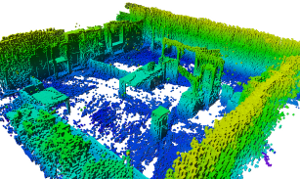
fr_078_tidyup.bt.gz (181 KB, 0.05 m res.)